Ambergate in Derbyshire is situated 6 miles south of Matlock and 10 miles north of Derby at the junction of the A6 trunk road and the A610 to Ripley, where the River Amber joins the River Derwent.
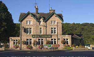
Hurt Arms in Ambergate |
Woods above Ambergate |
Until the railways arrived in the early nineteenth century Ambergate was known as Toadmoor and consisted of just a few cottages. In 1840 a railway station was built by the North Midland Railway Company called Amber Gate and the village of Ambergate was established, growing to 206 residents by 1851. The railway initally served the spa town of Matlock and Matlock Bath but by 1867 there was a through line from London St.Pancras to Manchester with an interchange for Leeds. The railway now, again, just serves the Matlocks from Derby.
St.Anne’s mission church opposite the railway station was built in 1892 and became the parish church in 1899.
The road ( turnpike ) to Matlock had been opened in 1818. Prior to that traffic north of Belper had to travel via Wirksworth until the Cromford Canal was built in 1794. Now Ambergate has a road, a canal and a railway passing through the village.
THe Hurt family were wealthy local industialists and in 1876 they built the Hurt Arms to replace the former 'Thatched House Tavern' that once stood there. In 1876 Richard Johnson and Nephew opened the wireworks across the river. Products from the Johnson's wire factory were once household names, with the company lorries carrying the slogan 'A wise buyer buys Johnsons wire'.
In 1966 the first fully operational electronic telephone exchange in Europe opened in Ambergate. This was also the first small to medium electronic exchange in the world.
The village still has a school , Ambergate Primary School, situated in Toadmoor Lane. There is also another pub called 'The White House' and a post office cum store which is situated next to the petrol station.
The Cromford Canal, running 14.5 miles fro Cromford to the Erewash Canal was last used as a working waterway in 1944. The canal can be explored from the towpath between Cromford Wharf and Ambergate, a distance of just over five miles. Because of is wealth of industrial heritage Cromford Canal is part of the Derwent Valley Mills World Heritage site as well as a nature reserve.
See also :
Matlock Bath
Cromford
Belper